Geometrics G-858 Cesium Vapor MagnetometerA very high resolution magnetometer for use in archaeological applications and locating unexploded ordnance (UXO) |

|
|
|
| The G-858
MagMapper is a high sensitivity, fast-sampling ‘walking’ magnetometer.
Its console includes a graphical interface that makes survey design and
data review simple and efficient. The G-858 provides various modes of
operation to allow users to custom design a survey grid for their
particular needs. Instrument operators have the ability to view their
position on the grid and the current data profile during the survey.
Display resolution, audible alerts, sample rate and many other functions
are user selectable.
G-858 data acquisition offers either continuous or discrete station recording. The high sampling rate of the instrument in continuous mode allows the operator to survey an area at a fast walking pace. A wider search zone can be achieved by adding a second sensor. Adding a second sensor also provides the ability to measure the magnetic field gradient. The G-858 is designed to interface easily with standard computers and peripherals. Geometrics encourages clients to provide their own processing computer hardware. Upon the client's request Geometrics will provide a complete and fully integrated processing station at a nominal price. Features:A basic software package - MagMap2000™, is supplied as an integral part of the G-858 system. MagMap2000 software included for:
G-858 data acquisition offers either continuous or discrete station recording. The high sampling rate of the instrument in continuous mode allows the operator to survey an area at a fast walking pace. A wider search radius can be achieved by using a gradiometer configuration. As a result, over-all costs are inherently lower while data quality remains high. The G-858 is designed to interface easily with standard computers and peripherals. |
|
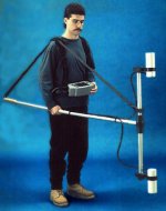 G-858 being used in gradiometer mode |
G-858 Options
|

For more info or pricing contact
Red Dog
Scientific Services, authorized representative for South /
Southern Africa