A Robust, Reliable and Affordable Magnetic
Mapping System
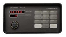
The G-857 provides excellent performance and is the
lowest priced professional magnetometer system available. With simple
operation, user friendly download/editing software, and format ready for
available commercial contouring programs, the G-857 represents a
complete magnetic surveying package generating high quality data for
budget conscious users
The newly re-engineered G-857 provides a
reliable, low cost solution for a variety of magnetic search and mapping
applications. Single key stroke operation means the G-857 can be
operated by non-technical field personnel or used in teaching
environments.
The G-857 uses the well-established
proton precession method, allowing accurate measurements to be made with
virtually no dependence upon variables such as sensor orientation,
temperature, or location. The unit provides a repeatable absolute total
field magnetic reading, traceable to the National Institute of Standards
and Technology. The unit offers new features such as
GPS time synchronization, GPS positions
and in-field navigation with a hand held Garmin GPS.
Applications: The
G-857 is ideal for mapping geological structures, for mineral
exploration, or magnetic search for industrial, environmental or
archaeological targets.
The optional gradiometer attachment gives greater resolution and noise
immunity for conducting searches in high cultural noise environments.
Simple operation, large digital data storage capability, and the
inclusion of MagMap2000 data transfer and editing software provides a
system well suited for both teaching and survey applications.
The automated cycling option with long sensor cable and external power
connection allows the G-857 to be used as a base station instrument for
the measurement of diurnal changes in the Earth’s magnetic field.
Diurnal correction data is then downloaded using MagMap2000 and can be
applied to either land or airborne magnetometer data.
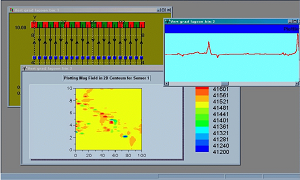
Superior Data Editing Software:
MagMap2000 allows rapid download of the data from the G-857 to a PC.
Data can be diurnally corrected, profile lines and X, Y or GPS positions
displayed and edited, noisy readings filtered and QC plots of profiles,
2D contour plots made. Data can be exported to Surfer, Geosoft or
MagPick (high end processing software free from Geometrics) for more
sophisticated final maps and analysis including Google Earth overlay
maps.
Specifications:
Resolution: 0.1 nT
Accuracy : Absolute 0.5 nT
Clock: Julian date, accuracy 5 sec
per month.
Tuning: Auto or manual, range
20,000 to 90,000 nT
Gradient Tolerance: 1000 nT/meter
Cycle time: 1.6 sec to 999 sec
standard
Read: Manual, or auto cycle for
base station use.
Memory: 65,000 field or base
station readings
Display: Six digit display of
field/time, three digit auxiliary display of line number, day
Digital Output: RS-232, switch
selectable to 115200 baud.
For more info or pricing, follow the Geometrics pointer at the
bottom of this page or contact
Red Dog
Scientific Services , authorized representative for South /
Southern Africa

 The
G-857 is ideal for mapping geological structures, for mineral
exploration, or magnetic search for industrial, environmental or
archaeological targets.
The
G-857 is ideal for mapping geological structures, for mineral
exploration, or magnetic search for industrial, environmental or
archaeological targets.